The Panjiakou Dam, a concrete gravity dam, spans across the Luanhe River in Qianxi County of Tangshan Prefecture. First constructed in 1975 and named after a rural village that was submerged after filling.
In history, the Panjiakou also served as another minor pass city among the many found in the mountainous ring of the Jundu Mountains around Beijing. With the creation of the Panjiakou Reservoir, the Panjiakou Great Wall of China section, rather famously, was submerged by the mand-made lake. It's ruined remains, found running to the south east and north west of the Lake are still popular attractions for hikers and recreational visitors to what is now largely a scenic are and water rich summer get away.
The Panjiakou dam syphons off water destined for the cities of Tianjin and Tangshan more to the west. Making use of a water diversion system that was started in the year 1978 and completed in 1984, the water destined for Tangshan Prefecture is derived from the Panjiakou Reservoir from which it is transfered to the Douhe Reservoir which is situated on the western branch of the nearby Dou River (Dou He) which flows into Tangshan Prefecture.
Ostensably the Panjiakou serves for flood control and more recently has seen the installation of hydro-electric generators,
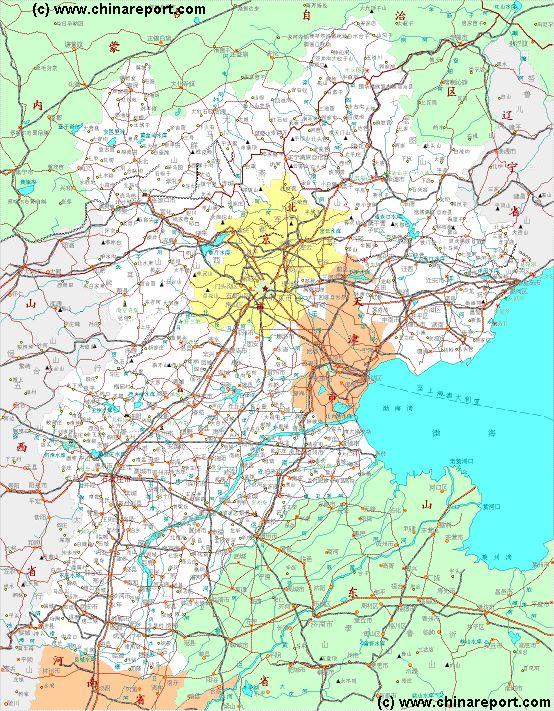
Main Rivers, Lakes and Waterways of Hebei Province :
GENERAL INFORMATION ON RIVERS IN HEBEI PROVINCE:
Hebei Province counts quite a few major and minor rivers. With most of north Beijing Province and northern Hebei Province being mountainous or at least hilly in appearance, an abundance of rivers flows from the high grounds through cavernous gorges and ravine's towards the lowland and usually finally the Bohai Bay of the Yellow Sea due east of Hebei Province. A high number of the rivers in the northern half of Hebei Province (and in the districts of Beijing) have been dammed, creating various reservoirs along the length of their trajectory. With a water shortage in both Beijing city and in neighboring Tianjin city, a large portion of the waters in these reservoirs are destined for consumption by the industry and citizens of those cities. The main other use for the reservoirs is the creation of hydro-electric energy and the use in agriculture in the region.
MAJIA RIVER:
Flowing from the west, the Zhujia River joins the Majia River as tributary near Donguoqiao (Cun) in the southern regions of Dezhou Prefecture of Shandong Province. (This village administrative unit is composed of the three parts, being the villages of Xiaogao (Cun) and Donguoqiao (Cun) on the north banks of both rivers and the village of Xigao (Cun) on the south banks).
Joined with the Zhujia River and flowing through rural regions into the extreme northern regions of Dongying Prefecture of Shandong Province, the Majia River finally passes the towns of Leling of Qingyun (zhen) before embarking on its lengthy end run through rural countryside. Terminates into the Bohai Bay of the Yellow Sea in the north of Cangzhou Prefecture of Hebei Province. Some kilometers before its ending point at the coastline, the river is joined by the Dehui River as a (final) tributary.
The Sanli River is a tributary river of the Luan River which runs through the town of Qian'An, the center of Qian'An County in Tangshan Prefecture. Once a clear mountain spring, by 1973 AD the Sanlihe was reportedly badly polluted, and at some point in time, likely after the year 1991 opening of the Malanzhuang Open Pit Iron Ore Mine and associated steel industries, the river dried up entirely laving but a polluted and garbidge filled concrete canal passing through town.
For over 10 years, the Sanli River did not exist except for during the rainy season when downpours filled the canal bringing yet more refuge and waste downstream to clog the remaining river canal.
Only as late as the year 2006 a thorough clean up of th living environment was launched in Qian An Town. With an eye on an envisioned urbanized existance for over a million in the near future, the entire Town of Qian'An was revamped. Redesignating the town as a City (a bump up on the adminsitrative ladder versus Beijing), the city center was revived by cleaning up waste dump and tapping into the nearby river Luan (Luan He) in order to rstore a waterflo to the long dead Sanli river.
The result is currently hailed as a great success and, probably with the added benefits of a great sales pitch for real estate developers, thetown of Qian'An has moreor less been elevated to the status of "model village", as they existed in the Mao Zedong years of the early Peoples Republic of China. No longer has Qian'An the face of a rural dump town, today's Qian'An is an expanding city with modern highrises and a 13.4 kilometer long "green heart created by reshaping, cleaning and restoring the Sanli River. In order to reshape the river, it has been recreated with green islands with groups of trees, wetlands that are intended as a natural filter to help clean its waters and abundant walkways and bicycle paths so that the local populace identifies with the life the river brings. Invisibly, the towns sewage run off, which previously joined the river without any previous clensing eforts has been seperated from the rivers flow, and various filters and treatment methods have been installed in the new city infra-structure in order to prevent fouled water from mixing with the clear stream of the Sanlihe.
What is not mentioned is the chronic over-consumption of water in the Regions, an important base of both mining and metallurgical industries. Although the Government hails the clean up of the Sanlihe River as a great success to be repeated elsewhere in the future, none of the reports of the project make mention of the longstanding pollution of groundwaters, local rivers and even the agricultural soil with heavy metals and other toxic residues reaching downstream from the Malanzhuang Open Pit Mine and various other smaller mines found along the upstream of the Sanli River and Luan River.
LUAN HE:
The Luanhe is one of the longest and most prominent rivers in Hebei Province. Originating near the village of Yangdian in situated between the county towns of Guyuan and Fengning in Zhangjiakou Prefecture of Hebei Province, the river winds its way up and down, passing through no less than 3 Prefectures of Hebei Province.
Along the way down from its source lie in succession the large Shandianhe Reservoir, Shuangshan Reservoir and the Dahekou Reservoir or Lake.
Continuing from Dahekou Reservoir it flows through Chengde Prefecture but not city of Chengde to reach two subsequent dams. The first of these is the Panjiakou Dam.
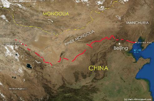
Link: Satellite Image with Schematic of the Location and path of the Great Wall of China during the Ming Dynasty. Visitable Locations & Passes on the Great Wall included.
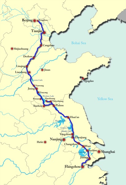
Although not a natural river proper, last but by no means least should be mentioned the historic Grand Canal of China which with its 1794 kilometers (1115 miles) in length cuts across (mainly) the Cangzhou Prefecture of Hebei Province. Connecting Beijing via Tongzhou and Tianjin Prefecture with cities far down south. Initiated as a humongous public works project as early as in the Sui Dynasty Era (581 AD - 618 AD) and completed in the years of the Ming Dynasty (1368 AD - 1644 AD), this longest man-made river in human history is legendary and considered one of the treasured features of the regions.
But a relatively short section of the Canal flows through Hebei Province however where, along with some its historical treasures, it is one of the major tourist sights to go see.
LAKES IN HEBEI PROVINCE:
Although there are many rivers of varying size in Hebei Province, for various reasons there is no abundance of Lakes in the Province except for the large Baiyangdian Lake.
Baiyangdian Lake is situated in Baoding Prefecture some 200 kilometers due south of Beijing and serves and important regional function. Identified as the largest freshwater lake in North China it regionally recognized for its beautiful scenery. Especially popular, as elsewhere in China (P.R.C.), are the lotus flowers blossoming every where on the lake in summer. Unfortunately however, due to the wholesale environmental mismanagement, the Lake has been tainted with pollution and has lost much of its charms over the decades. Another victim of heavy industrialization and great economic success at staggering cost to the environment, the Lake has also dwindled in size during successive drought periods striking in recent years. Increased urbanization and the growth of the super-city of Beijing are factually over burdening the
Schematic Map of the trajectory of the historic Grand Canal of China, traversing Beijing, Tianjin, Hebei, Shandong, Jiangsu and finally a small portion of Zhejiang Province. Although overtime the landscape has changed and the canal is no longer a crucial economic artery feeding the Capital city many of the locks and parts of the Canal are still in use today.
naturally available water resources in the region. As a measure to counter this dire problem an expensive mega-project to channel water from rivers in south China into north China has been developed and is largely operational, however until at least 2014 the city remains heavily reliant on the pumping of groundwaters, which is also running out fast.
Other than Baiyangdian Lake, no large natural Lake can be found in Hebei Province today, although there are many smaller ones.
Naturally, up in the elevated and mountainous north man-made dams could and have been built. The main lakes of the current day Hebei Province are usually man-made lakes or reservoir created by the damming of local rivers, a technique that has been applied in many locations. In the Luanhe River in northern and north-eastern Province there are no less than three enormous reservoirs. Many more smaller reservoir lakes can be found along the length of the Great Wall of China in Tangshan Prefecture, Chengde Prefecture, Beijing City Province, and to a lesser extend Zhangjiakou Prefecture.
DAI RIVER:
The Dai River (Chinese: 戴河; Dàihé) is a river in Hebei, China that empties into the northwest Bohai Gulf near the city of Qinghuangdao and the Great Wall of China. The coast north of the Dai River mouth is generally rocky, while the coast to the south is sandy. A shipyard and a jetty are located on the east bank of the river mouth.
DAYUN RIVER (DAYUN HE):
As mentioned above, the Dayun River (Dayun He) is the largest river in Hebei Province. There is however sparsely little information to be found on the internet.
The Dayun River originates in XX and flows through the Handan and Cangzhou Prefectures of Hebei Province. Interestingly, in its final ten's of kilometers the Dayun River forms the border between Tianjin City Province (of China) which lies to the north and Cangzhou Prefecture which lies to the south of the river.
The final termination point of the Dayun River is the mouth of the river at XX, where it empties in the Bohai Bay of the Yellow Sea. This is an interesting area where one will also find (taken from north to south) the mouth of the Qingjinghuang Drainage Canal, the mouth of the New Ziya Waterway, the mouth of the north Paishui River as well as the mouth of the smaller Jiedijian River. In addition, a few kilometers farther down south the Nandapai River and the Huangnanpaigan River also empty into the Bohai Bay.
DEHUI RIVER:
The mouth of Dehui River is found in the extreme north of Cangzhou Prefecture not too far from the border with Tianjin City Province. Dehui River joins with the Majia River before finally joining with the waters of the Bohai Bay of the Yellow Sea.
The highest number of rivers can be found in the southern half of Hebei Province, starting almost immediately south of the limits of Beijing City Province proper.
The number of rivers and canals in the North China Plain in southern Hebei Province is in fact so high that locating a specific river or canal can be practically difficult for Foreign visitors and outsiders who are not familiar with the territory. One of the most complicated situations arises in the former flowbed of the Yellow River (Huang He) which shifted around 2 centuries ago to a more southern trajectory through Shandong Province) in the area of the former mouth of the river. The location of the former terminus of the Yellow River can be found on the southern border of Tianjin City Province and in the northern extremes of Cangzhou Prefecture of Hebei Province. Although the original river no longer flows there, a high number of smaller rivers and man-made canals still empties into the Bohai Bay in the area.
Some of the rivers in Hebei Province originate in the neighboring Province of Shanxi which is more mountainous and has a higher elevation.
The rivers of Hebei Province are in fact quite too many to mention, however the
main rivers in the Province could be listed (in alphabetical order) as follows; the Baigou River, the Dai River, the Dayun River (Dayun He), the Juma River (Juma He), the Luan River (Luan He), Qinglong River, the Taiping (Heavenly Kingdom) River, Xiaoqing River (also in Fangshan District one of the 6 outer suburbs of Beijing), Yongding River, the Zhang River, etc.
The Daqing River (大清河), Sanli River (Sanlihe), Yixun River and Fuyang River (滏阳河)(situated in Xinhe county, Xingtai City Prefecture) are counted as among the tributaries of the larger rivers in the Province.
By far the largest river is the Dayun He, which flows through from west to east through southern Hebei Province before emptying into the Bohai Bay of the Yellow Sea.
Find the Rivers of Hebei Province described in more detail below.
The Yongding River is the main river found on the southern border of Beijing City Province and Baoding Prefecture of Hebei Province. Flowing down from the Fangshan District of Beijing, the river first enters the Zhuozhou County of Baoding Prefecture near Hanying Cun, a rural village on the Hebei Province side of the river. Onwards and downstream the river forms the border between the two administrative regions of Beijing and Hebei for a considerable distance. While in the border area the river meets the G45 Daguang Expressway which connects Daxing (District of Beijing) in the north to Gu'An (in east Zhuozhou County) in Hebei Province and destination further down south. Only a short distance further east the Yongding River also flows underneath the older G106 Provincial Road followed a few kilometers beyond by the new east-to-west Langzhuo Expressway which is still under construction at this time.
Now on a due eastern trajectory, the Yongding River then passes the village of Anyu (Cun) near which it then meets up with the Xintiantang River which flows from the north west adding itself as a tributary. Having joined with Xintiantang River the Yongding River flows past the town of Lanfang in eastern Zhuozhou County at only a few kilometers east of the Xinlong River which runs through the outskirts of the town of Lanfang.
Beyond Lanfang Town, the Yongding River enters into Tianjin City Province where a multitude of other rivers, canals and waterway can be found. The Yongding River receives the Xinlong River as tributary at a point south-west of the county city of Wuqing in Tianjin Province before eventually heading for the Bohai Bay of the Yellow Sea.
the first in 1981.
Today the Dam has a maximum capacity of 420 MW of which usually only half is actually generated. The Panjiakou Reservoir created by the dam measures 67 km2 (26 square miles) and is a popular getaway destination. Below the dam, the Luan River becomes the border river between Zunhua County and Qian 'An County as it continues southward to meet with the second large dam built in this area of Tangshan Prefecture.
The second dam along the Luan River is the elongated Daheiting Reservoir (Daheiting Shuiku - Latitude: 40.2225°, Longitude: 118.2958° ) in Qianxi County of the Tangshan Prefecture. The Daheiting Reservoir or Lake lies at a considerable distance south of the (Panjiakou) Great Wall of China at an elevation of 113 meter above sea level. Smaller than the Panjiakou Reservoir, the Daheiting Lake mainly serves a similiar purpose of collecting and storing water for consumption by the larger cities or for use in agriculture. With steep inclines rising up from the Lake, the landscape is hilly or mountainous with some forest
vegetation. There is little agricultural activity in the immediate area leaving much of the original flora (and some fauna) intact.
From Daheiting Reservoir the river Luan briefly continues southward before turning into an eastward direction and flowing into Qian 'An County on its way to Qian 'An Town, the administrative center and main market town there of.
Luan River in Qian 'An County:
Having turned eastward and finally braking free of the mountains and hills the Luanhe takes a turn southward for its final run through what are in effect the northernmost extenses of the North China
Qinhuangdao
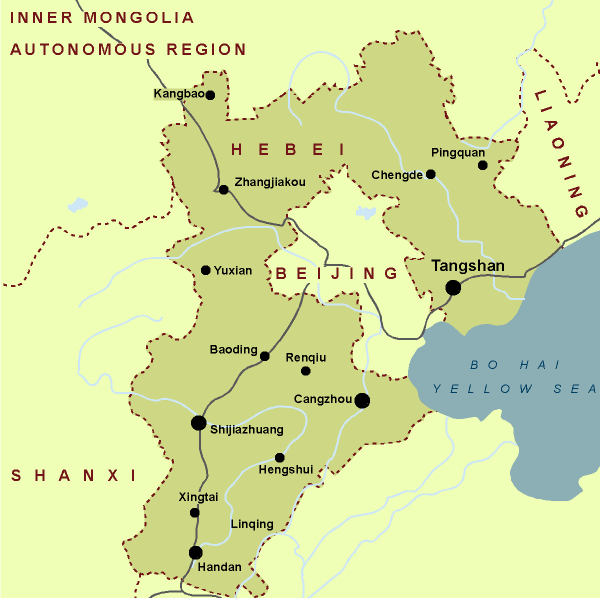
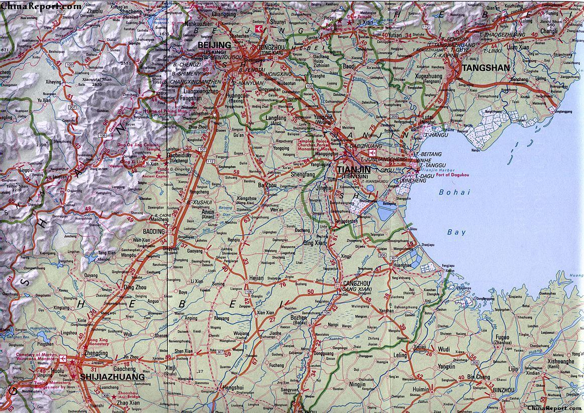
Schematic Map of Hebei Province, and within Beijing and Tianjin City Provinces.
JUMA RIVER:
Juma River (Chinese: 拒马河; Jùmǎhé) is a river in northern China that emerges from a spring-fed lake in Laiyuan County, of Baoding Prefecture in Hebei Province. From its origins the Juma He flows from Hebei into the Fangshan District in Beijing Municipality eventually emptying into the Daqing River, a tributary of the Hai River.
The total length of the river is approximately 254 km.
The Juma River is the main river in Fangshan District (one of the 6 outer suburbs of Beijing) where at a place named Shidu, the meandering river creates a deep valley in the scenic karst rock landscape. The "Grand Canyon" of Shidu so created is one of the main rural attractions and getaways from the summer hear in Beijing City Province.
At Zhangfang, the river forks into the Northern and Southern Juma, both of which flow into the Daqing (or Daxing) District of Beijing city. The Beijing–Yuanping Railway follows the Juma River through the Taihang Mountains.
Plain, the Luan He river heads for the County Capital of Qian 'An. The River passes the town of Qian 'An on the western side.
After passing the outskirts of the city of Qian 'An the Luan River initially heads in a southward direction through Tangshan Prefecture. But a few kilometers south of Qian 'An Town the Luan River meets the major east to west highway identified as G1Jingha Expressway and the older G102 County Road, which is the predecessor of the larger Expressway. Just south of these two important regional roads the Luan He is joined by the Qinglong River (Qinglong He), which as its name suggests originates out of the Qinglong Manchu
Autonomous County of the neighboring Qinhuangdao Prefecture of Hebei Province. The two rivers join in Qian 'An County just a kilometer or so south of G102 County Road, before their flow continues southward to meet up with the west to east G205 County Road which connects Tangshan City with Changli Town of Changli County. Beyond this road the river enters an area where the Luan River forms the natural border between Laoting County and the neighboring Changli County of Qinhuangdao Prefecture which lies East of the River.
In its last remaining length the River functions as border river between the two counties.
Luan River in Laoting County of Tangshan Prefecture:
Gradually turning eastward the Luanhe River continues through rural regions on the north border of Laoting County and eventually empties into the Bohai Bay of the Yellow Sea at a remote location identified as Luanhekou. Just before reaching the Luanhekou the river splits in a northern and southern branch effectively creating an island in the Bohai Bay. A pedestrian bridge connects the island to the mainland in the north-west corner of the island.
A smaller southern branch of the river, known as Luanhe Cha, flows due south and reaches the coastline and a more southern point.
TAIPING RIVER:
Taiping River (Chinese: 太平河 ; Taiping He) with a length of only 12.8 kilometers is a but a minor river in Hebei Province. It originates from the foot of Jing Fan Mountain and is a tributary of the nearby Jin River (Jin Jiang). Taiping River is located in the southwest of Shijiazhuang City Prefecture, the capital of Hebei Province and plays a role of releasing flood waters and supplying drinking water for citizens in that city.
In the recent decade, the river water quality was exceptionally bad and that in a Nation which overal serves from severe water and soil pollutions. Currently, due to pressure from environmental groups and the general public, this has officially been identified as a major problem. Currently, the local, Provincial and National Government are planning a systematic clean up, the most crucial part will be formed by constructing sewage treatement plants in cities along the river, thus hopefully capturing most of the yearly pollution.
Optimist believe that the Taiping River will once again be transformed into the scenic region it previously provided for city dwellers.
The Zhang River (漳河) is a major river found in the extreme south of Hebei Province. The River however originates as the Zhuozhang River far further to the east in neighboring Shanxi Province in the mountains south-east of Taiyuan City.
The Zhang River is significant as for a certain (brief) length it creates the natural border between Shanxi Province and Hebei Province. In addition a dam on the Zhang River diverts water into the formerly world renowned propaganda public works project known as the Red Flag Canal (situated on the border with Hebei- and Henan Provinces), formerly Nationally and Internationally known as a "Model" works of the New China and Maoist Era.
Once having crossed the border into Hebei Province, the river literally winds it way eastwards through the foothils descending off the mountainous border with Shanxi Province eventually meeting the Yuecheng Reservoir. From a point some ways beyond the Yuecheng Reservoir the river takes a north-western trajectory running straight up for quite a long distance before meeting up with the Wei River (Wei He; not to be confused with the more famous Wei River in Shaanxi Province) with which it then fuses at some distance south of Guantao Town near the border of Handan Prefecture (Hebei) with Liaocheng Prefecture of neighboring Shandong Province.
Since the year 2004 the county of Linzhang and with it much of the Zhang River in Hebei