Longquanyu Great Wall is continuous with Xishuiyu Great Wall.
Longquanyu (1) Introduction
This page was last updated: February 22, 2014
Great Wall of China in Beijing Province
ChinaReport.comat
Need we Say More? Great DVD on the even Greater Wall of China.
Buy it at Movie Universe - Click Here
Longquanyu Great Wall
Longquanyu Great Wall location coordinates: 40°16′60″ North 117°20′60″ East
The Longquanyu Great Wall is situated in Huairou District of Beijing City Prefecture.
In ...
Following their reports on crumbling watchtowers along the Longquanyu section
China Report - Map of the Gobi Desert & Yellow River Flow
A Satellite Image Map of the Entire Gobi Desert Region. Map overviews North-West Xinjiang Autonomous Region, Mongolia, Inner Mongolia and North and North-Eastern China giving a Full Overview of the Gobi Deserts. Clearly visible details of geographical features such as mountain ranges, rivers, valleys and lakes.
Map includes country borders, name and location details of Cities and Villages (clearly visible).
Mouse over Image to Reveal more information and follow the flow and path of the yellow river from Xining in Qinghai Province to the Bohai Sea. Details of old / former Yellow River flow (south of new) and new trajectory to the Bohai Sea.
Adjacent Map gives direct access to Longquanyu Wall Map by Google.
Learn more about the The Great Wall of China, Emperor Qin, his Terrecotta Armies and the horryfying fate of those who opposed him through this fascinating Film-Documentary.
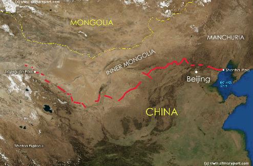
China Report - Map of the Great Wall during the Ming Dynasty
Satellite image of China and North-East Asia, with a super-imposed schematic Map of the location and Path of the Great Wall as constructed during the Reign of the Ming Dynasty. Included for reference are City names, geographical features of landscape, Names and locations of Passes on the Great Wall of China.