The Tibet Maps Index gives access to all Maps relevant to the Nation of Tibet and all Tibetan Area's. These include Tibet AR + Qinghai Province and larger Tibetan Area's of Specific Interest within the Himalayan Region, as used and/or produced by AsiaReport.com. Please use these Maps to find your way easily around Tibet, the Region, Cities, Area's and many Monuments & Landmarks.
Geographic Maps of the Silk Road Pathways, The Great Wall of China including in and near Tibet, the Military Commands of China, and the various historic maps relating to Tibet and Tibet AR.
Other Maps relevant to Tibet & History
Geographic Maps on Lhasa City and Area of Tibet AutonomousRegion.
Lhasa City & Prefecture Maps
Map China Ethno-Linguistic / Language Distribution Tibet & China
A Full and complete Map of China (PRC) identifying all Language Areas big and small in all Provinces and Autonomous Regions of China.
Map includes Turkic Languages (Uygur, Kazakh, Kirghiz, Salar & Uzbek), Mongolian Language and Sub-Divisions (Mongol, Tu, Daur and Dongxian), Tungusic Peoples (Oroqen, Evenki and Xibe) and Languages, Korean, Tajik (Tadzhik), Mon-Khmer (Kawa + Puman (or Pulang)), Hui, Uygur (Uighur), Tibeto-Bhurman Languages, Tai and Miao, Yao and She' Language Area's and Borders. Main Area's and sub-divisions of Han Languages (Northern Mandarin, Eastern Mandarin, South-Western Mandarin and Cantonese) further included. This color-coded ethno-linguistic Map (of 1967 AD) identifies at a glance most ethnic minority regions in China.
Schematic Map of the Yellow River Flow Path 01A
A Full Schematic Map of the entire flow path of the Yellow River. Map overviews Qinghai Province, Parts of Sichuan Province, Gansu Province, Ningxia Hui Autonomous Region, parts of the Republic of Mongolia, Inner Mongolia Autonomous Region, Shaanxi Province, Shanxi Province, Henan Province and finally Shandong Province, giving a Full Overview of the length of the Yellow River. Clearly visible details of geographical features such as mountain ranges, rivers, valleys and lakes. The Map includes main cities along the River, popular and famous scenic spots, the dams and water reservoirs on the Huang He and other relevant informations.
Click the links to find more information on each individual location !
MapTibetHistoricalBorders
A Schematic Map of Historical Tibet, today Tibet Autonomous Region, Qinghai Province, Gansu Province, Yunnan Province and a part of Sichuan province.
Included for reference are current Internationa Borders, provincial borders, locations and names of main cities and towns, main rivers and lakes, mountains,importantTibetan-BuddhistMonasteries and other places of significance.
Further Reports link to More Photos and History & Backgrounds of each City, Town or Ethnic Community of Yugur, Dongxiang Tibetan, Lhoba, Kazakh, Mongol or others where available.
Today Tibet only exists as Tibet Autonomous Region of China. Tourist visits require an aditional visa !
Map China 7 Military Districts (Regional Defense Commands)
Originally thirteen military regions were established in the 1950's, but the number was reduced to eleven in the late 1960's. The resulting eleven military regions - Shenyang, Beijing, Lanzhou, Xinjiang, Jinan, Nanjing, Fuzhou, Guangzhou (including Hainan Island), Wuhan, Chengdu, and Kunming - were reduced to seven intheperiod 1985-88 AD. Currently,the active military districts include Lanzhou- including the former Urumqi MR, part of the Himalayan Mountains in North-West Tibet andAksaiChin, Chengdu Military Region including the former Kunming MR, Nanjing, which includes the former Fuzhou MR, Beijing, and Shenyang. Finally Guangzhou and Jinan Military Regions both appear to include parts of the former Wuhan MR.
The military regions arefurther divided into military districts, usually contiguous with provinces, and military sub-districts.
Tibet AR - Lhasa City & Prefecture Maps - All :
Geographic Maps on Zhangye City and Area of the Hexi Corridor in Gansu Province.
Zhangye City & Prefecture Maps
Gansu Province - Zhangye City & Prefecture Maps - All :
Qinghai Province Map 1 - Geographic Map
A Geographic overview of Western China's Qinghai Province entire, delineating Provincial Borders and parts of neighboring Xinjiang-Uygur Autonomous Region, Gansu Province, Sichuan Province and Tibet (Xizhang) Autonomous Region. Includes Cities and Towns (shown by size), Main Monuments & landmarks, the flow of the yellow river in Qinghai Province, surrounding Bayan Har Mountain area's (TengGer),locations of Ethnic Minority Enclaves in Qinghai Province, Main Mountains (with Height), major highways, provincial railroads and main railroad-stations and main waterways & rivers. This Map further provides links to on site photos and information on Cities, Monuments and main transportation hubs of the wider Region.
Qinghai Province Map 2 - Schematic Map
A schematic overview of Western China's Qinghai Province entire, delineating Provincial Borders and parts of neighboring Xinjiang-Uygur Autonomous Region, Gansu Province, Sichuan Province and Tibet (Xizhang) Autonomous Region. Includes Cities and Towns (shown by size), Main Monuments & landmarks, the flow of the yellow river in Qinghai Province, surrounding Bayan Har Mountain area's (TengGer),locations of Ethnic Minority Enclaves in Qinghai Province, Main Mountains (with Height), major highways, provincial railroads and main railroad-stations and main waterways & rivers. This Map further provides links to on site photos and information on Cities, Monuments and main transportation hubs of the wider Region.
MapTibetHistoricalBorders
A Schematic Map of Historical Tibet, today Tibet Autonomous Region, Qinghai Province and a part of Sichuan province.
Included for reference are current International Borders, provincial borders, locations and names of main cities and towns, main rivers and lakes, mountains,importantTibetan-BuddhistMonasteries and other places of significance.
Further Reports link to More Photos and History & Backgrounds of each City, Town or Ethnic Community of Yugur, Dongxiang Tibetan, Lhoba, Kazakh, Mongol or others where available.
Today Tibet only exists as Tibet Autonomous Region of China. Tourist visits require an aditional visa !
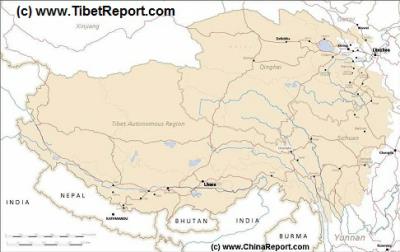
Tibet Autonomous Region Geographic Map 1A
This geographical Map gives a clear overview of Tibet Autonomous Region of China and immediate surroundings including neighboring area's of Xinjiang-Uyghur Autonomous Region in the North-West, Qinghai Province in the East. Due to the South and South-West lies Sichuan Province and in the extreme South-West Yunnan Province. Surrounding Nations are many, small and large. These are Myanmar, Bhutan, Sikkim, Nepal, Bangladesh, India and Pakistan.
Map Includes Cities and Towns (shown by size), Main Monuments & landmarks of TibetAR, main mountains (with Height), major highways, provincial railroads and main railroad-stations and main waterways & rivers.
A geographic overview Map of Tibet, the Tibetan Plateaux and relevant adjoining regions and territories. Map includes a large part of Xinjiang Uyghur Autonomous Region (PRC), Kashmir, North-West Pakistan, Northern India, Nepal, Bhutan, Bangladeshand the culturally associated region of Myanmar (Burma). A small part of Yunnan Province of China is also depicted.
This Map clearly defines disputed borders and territories, Nations (except for Tibet), Provinces and Regions, as well as geographical features such as main mountain ranges, main rivers & lakes of the region, basins and plains, plus the locations and names of main cities, towns, monuments and landmarks.
Browse the Map and follow the Links where available to access more maps, information and photos on each location and landmark.
Demographic Maps
Maps of Chinese Introduced Divisions to Tibet
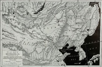
Mongolia Report - Historic Map Roy Chapman Andrews Expeditions 1922/30
A hand drawn Map from the hand of Roy Chapman Andrews depicting the various routes and locations relevant to his expeditions in East Asia between the years 1922 and 1930.
Map depicts north east Asia focussing on Inner- and Outer Mongolia. Map further the Tuva Republic, Irkutsk Oblast, the Trans-Baikal Region, Manchuria and the Russian Primorsky Krai Maritime Province. Other notable features are the Korean Peninsula, parts of north China, the Kokonor Region of the (then) independent Nation of Tibet, and the East Turkestan Republic or Territories (Xinjiang), at the time in disarray and under heavy Russian (Soviet and other) influence.
Click the Buttons and follow the Links to more information on each location and subject.
All Satellite Image based Maps and Satellite Images of Tibet and parts there of. Includes all Tibetan Areas of Tibet AR, Qinghai, Gansu, Sichuan and Yunnan (of the P.R.C.).
China Report - Tibet - Relief Map of Central Tibetan Plateau
A detailed Relief Map of Tibet - The Central Tibetan Plateau.
A Full Google Earth Supported Map of the PRC, Tibet & Tibet Autonomous Region by AsiaReport.com.
AsiaReport.com MasterMap of Asia Entire:
Browse the Peoples Republic of China, Mongolia, the Koreas and all National Capitals in Asia. Browse your location(s), click the Map Pins for Brief Information and Link Options. Link through to additional Online Chapter of location as well as additional Map info, photos and backgrounds.
Master Map of Asia includes all National Capitals in Asia, Provincial Capitals in The Peoples Republic of China, Rivers, Lakes and Waterways in The Peoples Republic of China, Provincial Capitals of Mongolia, Provincial Capitals and Cities in North Korea and South Korea.
-Map Edited nearly every day of every year! -
Asia Report.com - Master Map of Asia (Entire) - Asia Overview Map.
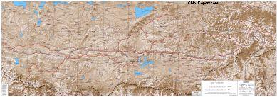
Tibet Railway Overview Map; All Stations o/t Tibetan Plateaux
A Chinese made Schematic Map of the route of the Tibetan Railway between Qining and Lhasa, the Capital of Tibetan.
Map by China Government sponsored ChinaTourMap.com.
Tibet T.A.R. Road Transport Map; Schematic Routes in TAR
A Chinese made Schematic Map of the road system in the Tibet Autonomous Region, T.A.R.
Map by China Government sponsored ChinaTourMap.com.
Transporation Maps
DONATE FUNDS.
All Funds donated will go directly into site development and the exploration of more historic sites in Tibet, Mongolia and the Peoples Republic of China, returning information for your benefit, entertainment and education. Thank You from DrBen, AsiaReport.com Staff and all Friends and Fans !
Maplandia Tibet Maps - Various Overview Maps of Tibet
A Collection of Maps of Tibet Autonomous Region and the (entire) Tibetan Plateaux. Very heavy on Chinese made maps depicting the Chinese created division of current day Tibet. Also useful Demographic and other maps.