Jinan, Jinan Prefecture, Capital of Shandong Province, China (P.R.C.). - Ancient Imperial Capital of China.
The below Map Image provides a quick overview of the Central and East Asian Region focussing on Inner- and Outer Mongolia. Map further includes parts of the Tuva Republic, Irkutsk Oblast, the Trans-Baikal Region, the path of the Trans-Siberian Railway and the Russian Primosky Krai Maritime Province. Notable fringe elements are the Korean Peninsula i/t East and parts of East Turkestan (Xinjiang) and the Kokonor Region (now Qinghai) of the Nation of Tibet.
Map was produced by R. Chapman Andrews for the Museum of Natural History and shows the route of his expeditions between 1922 and 1930 AD.
The China Report
Hand Draw Map of East Asia; Roy Chapman Andrews Expeditions 01 A
ChinaReport.com at
To Main Menu of All Websites at DrBen.Net
Go to www.drben.net webring
For a Complete List of all Ethnic Minorities in China - Click Here !!
China Maps
China Online Sources
China Offline Sources
China Online Store
China Photo Galleries
Satellite Maps
Art & Culture
History
DrBen.com Home
China Provinces /Home
DrBen.Net Partners
China
Asia Countries /Home
Asia
China Report Club
Blog
Chat
Forum
Provinces Maps
China Politics
China News
City + Site Maps
Historic Maps
This page was last updated on: May 7, 2017
My Great Web page
China Travel Community | Promoot jouw pagina ook
Sainshand
Bayan Obo
Dandong
Vladivostok
Blagoveschensk
Lanzhou
Qiqihaer
Jilin
Irkutsk
Khovd
Gobi Desert
Irkutsk, Capital of Irkutsk Oblast, Russian Federation.
Chita
Beijing, Beijing City Province, Capital of China (P.R.C.).
Lanzhou, Lanzhou Prefecture, Capital of Gansu Province, China (P.R.C.).
Yinchuan, Yinchuan Prefecture, Capital of Ningxia Hui Autonomous Region, China (P.R.C.).
Zhangjiakou
Zhangjiakou (Kalgan), Zhangjiakou Prefecture, Hebei Province, China (P.R.C.).
Tibet
Tibet
Click to go to Full Version !!
Map History - Schematic Asia - Russia China Britain Great Game 1900 AD
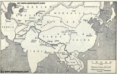
Schematic Map of Historical East Asia around the year 1900 AD.
Although the Manchu ruled Qing Dynasty Empire had previously conquered large parts of East Asia, including much of Korea, parts of current day Siberia, most of Mongolia, East Turkestan, Kyrgyz, Kazakh and other tribal lands while subjecting Tibet, remote and inaccessible behind its mountainous walls, to a subjugary role. At the turn of the 20th Century the outer regions of the Qing Empire have been eroded away, much of the north and west increasingly under Russian control while in the south and along the coast Britons and others had fought their way into the Chinese Realm. Notably, Korea has been annexed by Japan and Tibet is shown as a de facto independent territory. Tibet will be invaded by Britain in 1901 AD and will declare Independence not long there after at the fall of the Manchu Dynasty and the end of Manchu rule over China but also Mongolia and Manchuria in 1911 AD.  Other groups such as Mongolians, Kazakhe and Kyrgyz will likewise attempt to reestablish their National independence after the fall of the Manchu Empire.
Historic Map China (Qing) Empire in 1910 AD
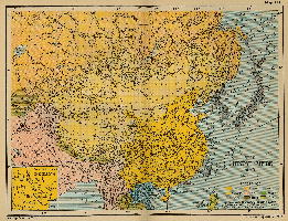
An obviously non-Chinese but western-made Map of the Qing Dynasty Chinese Empire in the year 1910 AD, a year in which China's sovereignty has been under threat and siege for over 70 years.
In this Map of 1910 AD, made one year before the abdication of Last Ching Emperor Xuan Tung (a.k.a. Aisin-Gioro Pu Yi) and the final end of China's Feudal History, China is depicted as in its smallest boundaries and definition. Most notably Manchuria, and Inner Mongolia, both territories nominally under Chinese Control and under Chinese Sovereignty are depicted as separate area's.
Other interesting features of the Map and geography of the Time : after the Sino-Japanese war of 1899 AD, both Korea and the Island of Formosa (now Taiwan / ROC) have been annexed by the Japanese Empire.
Map of China - Ching Dynasty Empire in 1910 AD
Shenyang
Shenyang (Mukden), Former Capital of Manchuria - now: Capital of Liaoning Province, China (P.R.C.).
Jilin City, Jilin Province, China (P.R.C.).
Hailar, Hailar District, Capital of Hulunbuir League, Inner Mongolia Autonomous Region, China (P.R.C.).
Hailar
Qiqihaer, Qiqihaer Prefecture, Heilongjiang Province, China (P.R.C.).
Amur
Amur
Uliastai
Khobdo (Khovd), Khovd Aimag, Republic of Mongolia.
Uliastai, (D)Zavkhan Aimag, Republic of Mongolia.
Ulan Bator
Urga (Ulaanbataar), Capital of the Republic of Mongolia..
Tsetserleg
Kaifeng
Kaifeng, Kaifeng Prefecture, Henan Province, China (P.R.C.). - Ancient Imperial Capital of China.
Tianjin, Tianjin City Province, Capital of China (P.R.C.).
Harbin, Capital of Heilongjiang Province, China (P.R.C.).
Jinan
Jinn, Jinan Prefecture, Capital of Province, China (P.R.C.).
Harbin
Yinchuan
Dalian
Dalian (Formerly: Port Arthur), Dalian Prefecture, Liaoning Province, China (P.R.C.).
1923
1922
1932
Tsetserleg, Arkhangay Aimag, Republic of Mongolia.
1925
1925
1925
Moron
Mörön, Khövsgöl Aimag, Republic of Mongolia.
Yellow
River
Xian
Xi An, Xi An Prefecture, Capital of Shaanxi Province, China (P.R.C.). - Ancient Imperial Capital of China.
Vladivostok, Capital of Primorsky Krai, Russian Federation.
Khabarovsk, -- Oblast, Russian Federation.
Khabarovsk
Chita, Zabakalsky Krai, Russian Federation.
Blagoveschensk, -- Oblast, Russian Federation.
1922
Shilka
Angara
Selenge
Hulun L.
Kerulan
Taiyuan
Dandong, Dandong Prefecture, Liaoning Province, China (P.R.C.).
Taiyuan, Taiyuan Prefecture, Shanxi Province, China (P.R.C.). - Ancient Imperial Capital of China.
Buir
Lui
Wei
Yellow
River
Yellow
River
Zhangjiakou (Kalgan), Zhangjiakou Prefecture, Hebei Province, China (P.R.C.).
Bayan Oboo (Mining District), Baotou Prefecture, Inner Mongolia Autonomous Region, China (P.R.C.).
1925
1933
1928
Bayan-
Khongor
Bayankhongor, Bayankhongor Aimag, Republic of Mongolia.
Bagakhangai, Bagakhangai District, Ulan Bator, Republic of Mongolia.
Sainshand (Formerly: Ude), Dornogovi Aimag, Republic of Mongolia.