This page was last updated on: May 31, 2017
54511
Transport in Tibet Autonomous Region of China
To Main Menu of All Websites at DrBen.Net
ChinaReport.com at
Go to www.drben.net webring
Tibet Autonomous Region (Xizhang)
Capital of Tibet (Xizhang) AR - Lhasa
Surface Area / Size - XXXXX square kilometers
Population - 2,840,000 (2004 AD) - Stabile
The
Great Wall of China, Qinhuangdao, China
The Great Wall of China, Qinhuangdao, China Photographic Print
Su, Keren
Airports
Lhasa Gonggar National Airport
Qamdo Bangda Airport
Nyingchi Airport
Ngari Shiquanhe Airport/planned:Tawa Airport
Full Introduction to Tibet (Xizhang) AR - Soon !!
Tibet Offline Sources
Tibet AR
Lhasa Landmarks
Lhasa Online Sources
Lhasa
Lhasa Home
Lhasa Hotels
Lhasa Maps
Tibet AR Home
Lhasa Transport
Ngari
Gar Home
China Offline Sources
AsiaReport.com Home
China Report Home
China Online Sources
China Online Store
China Maps
China
China Photo Galleries
China Report Club
This Page is under Construction.

No information available at this Time. Please use available Maps.
Buy this video - Exploring the World's Deserts
Nagqu
Nagqu Home
Jiayuguan Pass, Great Wall, China
Jiayuguan Pass, Great Wall, China Photographic Print
Su, Keren
Schematic Map of the many sub-pathways of the Silk Road in China clearly showing the one-unavoidable pathway of the Hexi Corridor.
Dunhuang, Gansu Province, China
ZhangYe, Gansu Province, China
JiaYuGuan, Gansu Province, China
Lanzhou, Capital of Gansu Province, China
Xi'An, Cpaital of Shaanxi Province, China
Qilian Mt Range
Mazhong
Mt Range
Taklamakan Desert
Qinghai Plateux
Gobi Desert
Gobi Desert
Tibetan Plateux
Tian Shan
Mt Range
Urumqi, Capital of Xinjiang-Uygur AR, China


CD Universe - Buy Video Games for Nintendo Wii, PlayStation 3, XBox 360, PlayStation 2, XBox, Sony PSP, GameCube, PC Games at Every Day Low Prices
Kashi or Kashgar, Xinjiang-Uygur AR, China
The Great Tale of a Journey to the West - set in Modern China !
DVD Documentary "China Oddessey", Cultural China as never before. Based upon the Classical Tale, a journey to the West. Available on Blue-Ray Disc - Click Here
Uzbekistan
To China Report - Index/Main Menu


CD Universe - Buy Video Games for Nintendo Wii, PlayStation 3, XBox 360, PlayStation 2, XBox, Sony PSP, GameCube, PC Games at Every Day Low Prices
Help tell the Story of Tibet Autonomous Region, shop for Music Online !
Wuwei, Gansu Province, China
Tianshui, Gansu Province, China
Xining, Capital of Qinghai Province
Click Map to go to Full Version !!
Coqen
Gyirong
Pakistan
Butawal
Gorakhpur
Kanpur
Lucknow
Benares
Muzzaffarpur
Dharan
Nyalam
Xixabangma Feng (8027 Meters)
Kathmandu
Thimpu
Batang
Shangri-La
Serxu
Mapam
Yumco
Za'Gya Zambo
Nam
Co
Siling
Co
Dulan
Qumarleb
Madoi
Yushu
Delhi
Da Qaidam
Budongquan
Amdo
Zogang
Barkam
Xainza
Nyima
Qamdo
Baingoin
Gerze
Zanda
Rutog
Lhaze
Xigaze
Nagqu
Gar
Baiyi
Nedong
Click to go to Full Version !!
Map Tibet Historical Borders
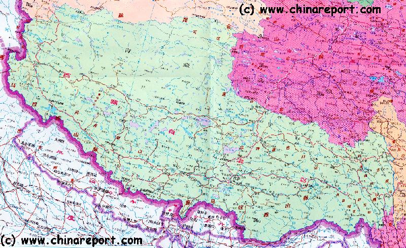
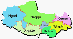
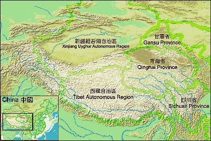
A Schematic Map of Historical Tibet, today Tibet Autonomous Region, Qinghai Province and a part of Sichuan province.
Included for reference are current International Borders, provincial borders, locations and names of main cities and towns, main rivers and lakes, mountains, important Tibetan-Buddhist Monasteries and other places of significance.
Further Reports link to More Photos and History & Backgrounds of each City, Town or Ethnic Community of Yugur, Dongxiang Tibetan, Lhoba, Kazakh, Mongol or others where available.
Today Tibet only exists as Tibet Autonomous Region of China. Tourist visits require an aditional visa !
Some Amazing Tibet DVD Documentaries available from Our Online Store !!
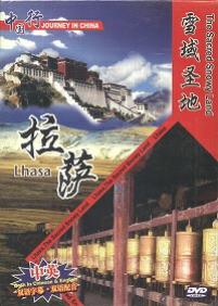
Source DVD "Tibet - sacred, mysterious, ancient, primitive"
( available from our Online Store )
All the details and the Timeline on the Great Lamas of Tibetan History !
Source Book
"Biographies
o/t Dalai Lama's"
( available from our Online Store )
Original Film Documentary with Magnificent Images - Joy to Watch !!
A Magnificent film documentary on Qinghai, Tibet and Mongolia, All destinations along Marco Polos route over the roof of the World. - Click Here
One of the Epic Movies dpeictinga Clim to the Top !
An attempt to Summit Mount Everest. Filmed from Start to Finish with the Complete Struggle. Must See !
Buy it - Click Here
Tibet - Tibetan Plateaux - Satellite Image Overview 1A
A Satellite Image overview Map of the entire Tibetan Plateaux including parts of bordering regions of Xinjiang-Uyghur AR, Gansu Province, Ningxia Hui AR, Inner-Mongolia AR, Sichuan Province, and Yunnan Province. Surrounding nations and Territories are: Myanmar (Burma), Bhutan, Sikkim, Nepal, Bangladesh, India, Kashmir and Pakistan.
This Map clearly defines Provinces and Regions, main mountain ranges, main rivers & lakes of the region, locations of main cities and landmarks.
Tibetan Plateaux Satellite Overview
Satellite Image Overview of the Tibetan Plateaux !!
Nedong
Gar
Nagqu
Baiyi
Xigaze
Lhasa
Lhasa, Capital of Tibet Autonomous Region
Lhaze
Rutog
Zanda
Gerze
Baigoin
Qamdo
Markam
Zogang
Bomi
Bomi
Xainza
Nyima
Amdo
Golmud
Golmud (Qinghai Province)
Da Qaidam
Budongquan
Yushu or Kyigudo (Qinghai Province)
Tangula
X<- Pass
Delhi (Qinghai Province)
Madoi (Qinghai Province)
Qumarleb (Qinghai Province)
Dulan (Qinghai Province)
Har
Hu
Gyaring
Hu
Shangri-La (Yunnan Province)
Sichuan
Yunnan
Qinghai
Xinjiang-Uygur AR
Nepal
Bhutan
India
Sikkim
Indus
River
Ganges
River
Brahmaputra River
Tsangpo
Brahmaputra River
Batang (Sichuan Province)
Serxu (Sichuan Province)
Gangtok, Capital of Sikkim
Thimpu, Capital of Bhutan
Kathmandu, Capital of Nepal
Nyalam (Tibet AR)
Yadong (Tibet AR)
Dharan (Nepal)
Muzzaffarpur (India)
Patna (India)
Patna
Gorakhpur (India)
Lucknow (India)
Kanpur (India)
Benares (India)
Butawal (Nepal)
Gyirong (Tibet AR)
Mount Everest - K1 - Qomolama Feng (8841 Meters)
Api (7192 Meters)
Nyainchentanglha Feng (7111 Meters)
Namjagbarwa Feng (7787 Meters)
Tangalu Shan (6205 Meters)
Dosoigangri Shan (5689 Meters)
Buka Daban Shan (6860 Meters)
Muztag Shan (6973 Meters)
Keriya Shan (6920 Meters)
Keriya->X
Pass
Coqen
Lancang
River
Click on Map to go to Full Version !!
Qamdo
Qamdo Home
Shannan
Nedong Home
Nyingchi
Nyingchi Home
Xigaze
Xigaze Home
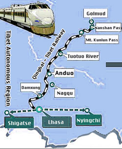
Transportation & Travel Connections in Tibet Autonomous Region :
RAILROADS IN TIBET AR:
Full Information Coming Soon !

ROADS & HIGHWAYS IN NINGXIA:
Main Road connections within Ningxia correspond with local natural boundaries and ancient travel routes.

AIRPORTS IN TIBET AR:
The airports currently available in Tibet are Gonggar Airport near Lhasa, Bamda Airport in Qamdo Prefecture and Mainling airport in Nyingchi County (林芝地区).

The Gunsa Airport in Ngari is scheduled to start operations on July 1, 2010, after which it is expected to become the fourth civil airport on the "Roof of the World".

Peace Airport for Xigaze prefecture is to be completed before the end of 2010.[22]

Nagqu Dagring Airport is expected to have the world's highest altitude airport by 2011 at 4,436 meters above sea level.

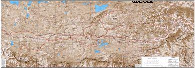
China Report - Tibet - Relief Map of Central Tibetan Plateau
China - Central Tibetan Plateau Relief Map - Small
A detailed Relief Map of Tibet - The Central Tibetan Plateau.
Overview Map of Tibet - Central Tibetan Plateau
China - Central Tibetan Plateau Relief Map - Medium
Tibet AR Economy
Tibet AR History
Source Book
"China's Great  Train"
( available from our Online Store )
The Complete Story behind the astonishing feat of the 'Tibetan Railway'
Find DrBen and ChinaReport on Facebook with the latest from www.drben.net.
DrBen Nijhoff | Maak je eigen badge
Click DVD Image to View Product in Store !!
Source DVD
"Journey in China - The Sacred Snowy Land - Lhasa
( available from our Online Store )
Soundbonus - Traditional Tibetan Sounds - Goodmorning in the Zhanskar Valley.
Tibet AR Monuments
Tibet AR Maps
Tibet AR Minorities
Tibet AR Transport
Tibet AR Wildlife