This page was last updated on: October 19, 2017
Another schematic map of the path and full length of the Silk Road depicting the Silk Road as it was during the later Roman Empire and beyond. Until perhaps as late as the 9Th or even 12Th Century the Path depicted was the main route of the Silk Road.
This Map is only a rough sketch, but includes all main trading cities and strategic strongholds along the Length of the Eurasian overland Trade-Route known as the "Silk Road". Interestingly it also depicts a small part of the Maritime Routes that lead from the Red Sea along the Persian Coast eastwards to India and beyond.

The Silk Road and Great Wall of China -
The first to be established was the Great Wall of China, which was first built by Ch'in Shi Huangdi during the short-lived Qin Dynasty (221 B.C. - 206 B.C.). Building on the success of the Great Wall the succeeding Han Dynasty (206 B.C. - 221 A.D.) sent emissaries to the North-West where Oasis Cities and Independant Kingdoms held valuable Treasures and Commodities. After much effort these missions and several military campaigns in competition with the Xiong-Nu Tribes of the North resulted in the establishment of the first trading route west to Parthia in the 2nd Century BC. Bactria with its Capital Bactra (Balkh in Afghanistan) was a rich source of magnificent tall and strong Horses which eventually acquired through exploration, trade and conquest gave the Chinese new Military Powers.
Gaining new strength and even greater mobility in battle with the strong horses, in 121-119 BC the Han Dynasty launch a Military Campaign to reach as far west as Buchara (current day Uzbekistan), finally defeating the Mongols in the Battle for Control of the Trade Route Oasis Cities and establishing a flourishing Trade Route to reach even Athens and Rome in the West. in a later Era, during the Tang Dynasty (618 AD - 907 AD) the Silk Road would flourish again, its pathways remaining in use until the advance of the iron horse train , the motor car and mostly overseas transport rendered most of it redundant.
The China Report
Map Asia - History - Macedonian Empire 336 BC - 323 BC
Wuwei
Yue Zhi
Badi
South Yue
Parthia
Persia
West
Taxila
The Great Wall that protected the Silk Road during Later Ages & Eras
ChinaReport.com at
To Main Menu of All Websites at DrBen.Net
Go to www.drben.net webring
A Former Part of the Imperial Inner City, now Park o/t Peoples Culture
Bactra (Balkh, Afghanistan)
Click to go to Map 1
Map 1 of the Silk Road during the early Tang Dynasty Era. Clearly depicts the North & South Routes West of Dunhuang as well as the lost civilizations of Loulan and Hotan.
Odessus (Varna, Bulgaria)
Corinth (Corinth, Greece)
DarDa
Palmyra (Ruins of Palmyra, Syria)
Leuce Island (Today Snake Island or Serpent Island, (Ukrainian: Острів Зміїний, Ostriv Zmiinyi; Romanian: Insula şerpilor)
Damascus (Damascus, Syria)
Tian Shan
    Mt.
         Range
Hormoxia (Hormuz)
Bulgaria
Danube
  River
Greece
Ukrain
Arabia
Sidon (Sidon, Lebanon)
Athens (Athens, Greece)
Babylon (Ruins of Babylon, Al Hillah, Babil Province, Iraq)
Sittace, Sittake or Sittakê ; Greek: Σιττάκη (Iraq)
Callatis (Today Mangalia (Romanian pronunciation: [maŋˈɡalia], ancient Callatis ; Greek: Καλλατις), other historical names Pangalia, Panglicara, Tomisovara, Constanţa County. Bulgaria)
Turkey
Syria
Danube
        River
Byzantium (Constantinopel; Today Istanbul, Capital of Turkey)
Don
  River
Heraclea Pontica ; Greek: Ηράκλεια Ποντική (Karadeniz Ereğli, Zonguldak Province of Turkey)
Pityus (Pitsunda ; Abkhaz: Пиҵунда, Georgian: ბიჭვინთა, Bichvinta; Russian: Пицунда - Resort Town in Gagra district, Abkhazia)
Abkazhia
Alexandria (Alexandria, Egypt)
Cnossos (Cnossos, Island of Crete, Greece)
Click to go to Silk Road Map 1 !
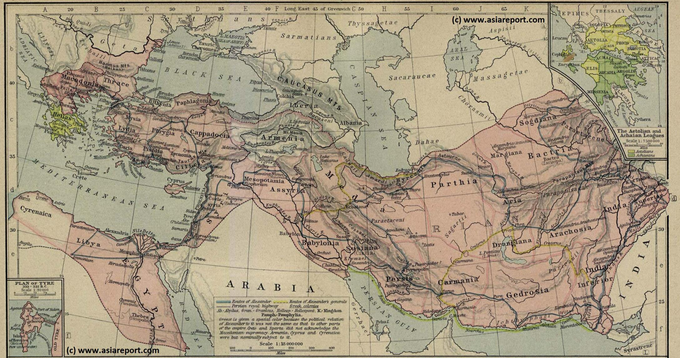
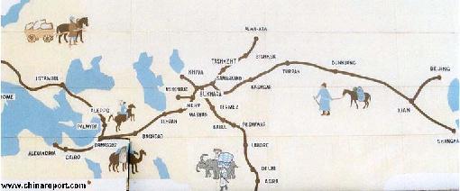
A 2nd Schematic Map of the Silk Road during the Roman Age. In 30 BC the Roman Empire started trading with India, which was already well known from the Conquest of Alexander the Great (+/- 330 BC). In the following 6 centuries the West would Trade with India and indirectly also with China through the Silk Road. The Silk Road only lost its Value after the European Age of Discovery and the Establishment of Maritime Trade Routes with India (16Th Century) and later China.
China Maps
Satellite Maps
China Online Sources
China Offline Sources
China Online Store
Art & Culture
History
China News
China Travel
DrBen.Net Home
China Provinces /Home
DrBen.Net Partners
China
AsiaReport.com Home
Asia
China Report Club
Blog
Twitter
Forum
Chat
DrBen Live TV
China Video Library
China Photo Library
China Politics
Provinces Maps
City + Site Maps
Historic Maps
China Travel Community | Promoot jouw pagina ook
Niniveh (Iraq)
Tyrus (Tyrus, Lebanon)
Oxus
  River
Acira (or Angora; Today: Ankara, Capital of Turkey)