The Hainan Province Maps Index gives acces to all Maps relevant to Hainan Province and area's of Specific Interest within that Region, as used and/or produced by ChinaReport.com. Please use these Maps to find your way easily around the Region, Cities, Area's and many Monuments & Landmarks.
Geographic Maps on Haikou City and Area of Hainan Province.
Haikou & Prefecture Maps
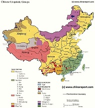
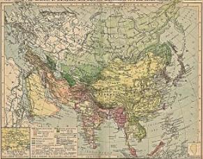
Map China Ethno-Linguistic / Language Distribution Tibet & China
A Full and complete Map of China (PRC) identifying all Language Areas big and small in all Provinces and Autonomous Regions of China.
Map includes Turkic Languages (Uygur, Kazakh, Kirghiz, Salar & Uzbek), Mongolian Language and Sub-Divisions (Mongol, Tu, Daur and Dongxian), Tungusic Peoples (Oroqen, Evenki and Xibe) and Languages, Korean, Tajik (Tadzhik), Mon-Khmer (Kawa + Puman (or Pulang)), Hui, Uygur (Uighur), Tibeto-Bhurman Languages, Tai and Miao, Yao and She' Language Area's and Borders. Main Area's and sub-divisions of Han Languages (Northern Mandarin, Eastern Mandarin, South-Western Mandarin and Cantonese) further included. This color-coded ethno-linguistic Map (of 1967 AD) identifies at a glance most ethnic minority regions in China.
Map China 7 Military Districts (Regional Defense Commands)
Originally thirteen military regions were established in the 1950's, but the number was reduced to eleven in the late 1960's. The resulting eleven military regions - Shenyang, Beijing, Lanzhou, Xinjiang, Jinan, Nanjing, Fuzhou, Guangzhou (including Hainan Island), Wuhan, Chengdu, and Kunming - were reduced to seven intheperiod 1985-88 AD. Currently,the active military districts include Lanzhou- including the former Urumqi MR, part of the Himalayan Mountains in North-West Tibet andAksaiChin, Chengdu Military Region including the former Kunming MR, Nanjing, which includes the former Fuzhou MR, Beijing, and Shenyang. Finally Guangzhou and Jinan Military Regions both appear to include parts of the former Wuhan MR.
The military regions arefurther divided into military districts, usually contiguous with provinces, and military sub-districts.
Hainan Province - Haikou City & Prefecture Maps - All :
Geographic Maps on Sanya City and Area of Hainan (Island) Province.
Sanya & Prefecture Maps
Hainan Province - Sanya City & Prefecture Maps - All :
Guangdong Province Map Index Page. All overview Maps of Guangdong Province, Guangzhou and other Cities in Guangdong, major landmarks and monuments, roads and highways, railroads and rivers, plus more.
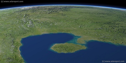
Asia Report - Map Image of South China, Gulf Tonkin, Hainan Island
This Satellite Image provides a clear overview of Hainan Island Province of China, The Gulf of Tonkin, large parts of Guangdong Province, Yunnan Province, Guanxi Zhuang Autonomous Region, Guizhou Province, Sichuan Province and Hunan Province of China; as well as parts of Northern Vietnam, Laos and Myanmar.
Marked on the map for orientatation are the names of major National and Provincial Capitals, cities, several towns and villages, oceans, sea's, lakes and rivers, as well as mountains, national borders, and locations of interest.
Browse the map and follow the links to more information, maps and photos of each location.
China Report - Map China Ethno-Linguistic / Language Distribution China (P.R.C. & Taiwan R.O.C.) 02
A smaller rough schematic Map of China (PRC) identifying the Zones of in which the Main Groups of languages spoken throughout the Nation can be easily identified. The 4 main language groups; sino-tibetan languages, indo-european, austro-asiatic and altaic are further subdivided to region, province and Autonomous Regions as based on the 1964 Ethno-Linguistic Map.
Map further includes Turkic Languages (Uygur, Kazakh, Kirghiz, Salar & Uzbek), Mongolian Language and Sub-Divisions (Mongol, Tu, Daur and Dongxian), Tungusic Peoples (Oroqen, Evenki and Xibe) and Languages, Korean, Tajik (Tadzhik), Mon-Khmer (Kawa + Puman (or Pulang)), Hui, Uygur (Uighur), Tibeto-Bhurman Languages, Tai and Miao, Yao and She'
Language Area's and Borders. Main Area's and sub-divisions of Han Languages (Northern Mandarin, Eastern Mandarin, South-Western Mandarin and Cantonese) further included. This color-coded ethno-linguistic Map (of 1967 AD) identifies at a glance most ethnic minority regions in China.
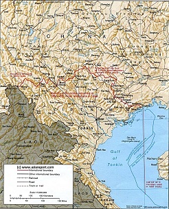
Vietnam border territories with China (P.R.C.) - Geographic Overview Map 1A
A geographic overview Map of the northern half of the Republic of Vietnam and southern provinces of the Peoples' Republic of China, with an emphasis on the delineated borders between the two.
Map includes a large part of Yunnan Province (PRC), Guangxi Zhuang Autonomous Region and Guizhou Province of China (P.R.C.). as well as parts of Laos and the Kingdom of Thailand.
This Map clearly defines disputed borders and territories, Nations, Provinces and Regions, as well as geographical features such as main cities, rivers & lakes of the region, basins and plains.
Browse the Map and follow the Links where available to access more maps, information and photos on each location and landmark.
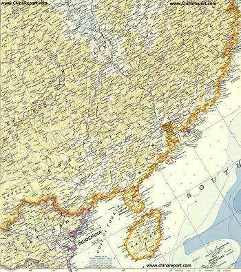
China Report - Historic Map - North Vietnam & South China in 1953
A large Geographic Map of parts of South China and North Vietnam in the year 1953 AD when the Peoples Republic of China was only 4 years old, the Korean war had recently ended in a stale-mate (which continues to this day) and at the same time the partition of Vietnam into Ho Chi Minh's Socialist Republic of North Vietnam and the American supported South Vietnam was just about to be formalized (1954 Geneva Convention) and taking shape.
Map includes parts of Guizhou Province , Yunnan Province, Sichuan Province, Hunan Province, Fujian Province, Guangxi Zhuang Autonomous Region, Guangdong Province and finally Hainan (Dao) Province of China (P.R.C.). In addition most of the northern "bulge", a total of 26 of the 50 Provinces of the Socialist Republic of Vietnam are depicted. The Provinces shown are Dien Bien, Lai Chou, Lao Cai, Ha Giang, Cao Bang, Son La, Yen Bai, Tuyen Quang, Bac Can, Thai Nguyen, Lang Son, Phu To, Boc Giong, Vinh Puc, the National Capital of Hanoi, Bac Ninh, Huai Duong, Hung Yen, Han Nam, Quang Ninh, Binh Hoa, Ha Tay, Ninh Binh, and the small coastal provinces of Nam Dinh, Thai Binh and Haiphong (City).
The Map makes use of old westernized spelling (Wayde Giles) and where possible current names of cities and towns.
Link through where available to find more information and additional details on each location and region as marked on the Map.
Military and related maps relating of Hainan Province.
Military Maps relevant to Hainan
Historic Maps on Hainan Province.
Historic Maps relating to Hainan Province
Asia China Mongolia Transportation - Airports & Railroads Satellite Map
This Satellite Image provides an overview of all International Airports in Asia, all Airports in China (PRC) and Mongolia. In addition all military airbases in China (PRC) listed.
Navigate map and click pins for additional information and video where available. Link through from any pin to location information and backgrounds.
Overview all transportation in the Peoples Republic of China and additional Asian Nations in one glance.
Direct Hotel & Resort booking + additional packages linked by location across China, Mongolia and neighboring Asian Nations.
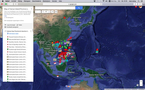
Asia Report - Map of Hainan Island Province including South China Sea Prefecture
This Google supported Satellite Map provides a clear overview of Hainan Island Province of the Peoples Republic of China, including its South China Sea Prefecture. Map of the South China Sea further includes parts of Taiwan and coastline, Gulf of Tonkin, coastline of Vietnam, Brunei, Borneo (Malaysia), and western Philippines.
Marked on the map for orientation are the names of major National Capitals, locally relevant cities, several towns and villages, names of oceans, islands in the South China Sea, as well as locations of interest such as naval bases, artificial island, airfields, tourism locations, etc.
Browse the map and follow the links to more information, maps and photos of each location.
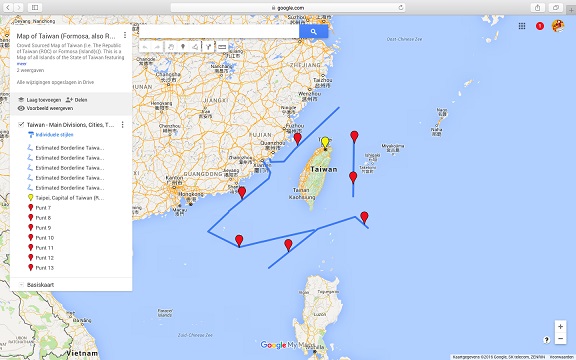
Asia Report - Map of Taiwan; Island of Formosa incl. parts of South China Sea
This Google supported Satellite Map provides a clear overview of the Island Nation of Taiwan, factually independent but also claimed as a Province of the Peoples Republic of China. Map includes National territorial limits,main administrative divisions, main cities, mountains, historic locations, scenic spots and tourism locations. Taiwan territory de facto includes parts of the South China Sea, larger part of which is also claimed by Taiwan as Republic of China (ROC).
Browse the map and follow the links to more information, maps and photos of each location.
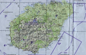
Map of Hainan Island incl. parts of South China Sea (in 1984)
This Geographical relief Map provides a clear overview of the Island of Hainan, center of the Hainan Island Province of the Peoples Republic of China, which also includes amll parts of the South China Sea. In addition, the Hainan Island Province includes a much larger still internationally disputed terrirtories and parts of the South China Sea, so designated by the PRC as South China Sea Prefecture of Hainan Island Province. While the Peoples Republic of China claims a much larger area this map focusses on the central Island of Hainan.
Map includes National territorial limits, main administrative divisions, main cities, mountains, historic locations, scenic spots and tourism locations.
Browse the map and follow the links to more information, maps and photos of each location.
Asia Report - Map Trade Routes in Asia in the 13Th Century
A Schematic Map of the Eurasian Trade Routes existing in the 13Th Century. Clearly marked in Red Accent on the Map are the cities of the network of land-bound trading routes through Central Asia known as the Silk Road (the path of Marco Polo and others). Marked in Blue Accent are the Main Ports and Harbors of the Maritime Trade Routes that operated between the Arabian Peninsula and the Red Sea, the Indian Ocean and Coastal Cities, the Straights of Malacca, the South-China Sea's and beyond. As shown Maritime Trade to China mainly entered through Southern Harbors, then was distributed internally by use of the Grand Canal, the Yangtze River and the Yellow River.
Map includes the Route travelled by Marco Polo, William of Rubruck and John of Pian de Carpine, the three famed European Travelers of the Time.
Locations of Main Trading Ports and Cities on Trade Routes of the Time are marked.
China Report - Colonialism - Growth of Colonies & Japan after 1801 AD
A Map drawing of the Eurasian continent , parts of North-East Africa and the Middle East in the 19Th Century between 1801 AD and 1900 AD. Focal points are the expansion of western colonial posessions of Portugal, Britain and France, as well as Russia moving from West to East. Labeled seperately is the later Rise of the Empire of Japan in the East.
Included in this Map are the main cities across the continent with their brief histories and events during the 19Th Century. Marked in Colors for clarity are the various colonial and imperialist Nations. As relating to China; special attention is payed to so called Treaty Ports. The First Treaty Ports were forced open by Britain in the year 1841 AD, but counted over 80 in total by the end of the 19Th Century. The most important Treaty Ports in China are marked and described with a short history where the map allows. Follow the links for more information on each location and subject.
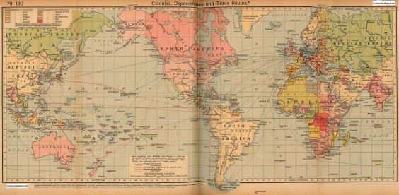
Colonialism - 1912 World Map of Colonial Possessions & Trade Routes.
A Map drawing of the World depicting the Colonial Possessions as they were distributed in 1912 AD. Superimposed and marked in colors are subsequent changes in Influences Spheres, colonies and possessions due to World War I ( 1914 AD - 1918 AD). Included in this Map are the main cities across the continents with their brief histories and events during the late 19Th Century and early 20Th century, where relevant. Marked in Colors for clarity are the various colonial and imperialist Nations. As relating to China; special attention is payed to so called Treaty Ports. The First Treaty Ports were forced open by Britain in the year 1841 AD, but counted over 80 in total by the end of the 19Th Century.