This Map of the Former Legations Area in Beijing depicts a Mix of historic details and current day items.
First of All, the Legations Area of current day Beijing is bordered in the West by TiananMen Square, bordered to the North by East Chang An (Eternal Peace) Avenue, bordered in the West by ChongwenMen North Street (Nei Dajie') and last, bordered to the South by QianMen East Street (=Dong Dajie'), at the location of the Former City Wall and Moat.

The West Border of the original former Legations Area extended as far as what is now the National Museum of History (formerly The Museum of the Revolution & The Museum of Chinese History) which was constructed on the ruins of buildings burnt down during the 1900 AD Boxer War in Beijing. As one can tell from the Map these included among things the Mongol Market and the Imperial Carriage Park, an adnex of the Imperial Palace, at Chang An Avenue. The National Museum of History was constructed in the 1950's as part of the new Architecture of Post-Revolutionary TiananMen Square.
As mentioned, the North Border today, as in the Past, is the historic and important Chang An Avenue, which leads along the Northern Side of TiananMen Square and Tian An Men Gate of Heavenly Peace. The Only changes to this area are the disappearance of the Outer Imperial City Walls and Gates in the Area where Zheng Yi Road, Nanchizi Dajie', NanHeyuan Dajie' and Chang An Avenue come together. Only one of the Gates remains standing today, giving access North to Nanchizi Dajie' and the Park of the Peoples Culture. The bridge which stood at the North End of Zheng Yi Lu (=the "Canal Street"), in front of the Gate giving access to TiananMen Square in the past has disappeared along with the Gate.
Introduction to Beijing Former Legations Quarter Map 1900AD Boxer War
To Ming Dynasty City Wall Relics Park
Oriental Plaza
Beijing Supreme Peoples Court
To Tian an Men Square
TiananMen -
Gate of Heavenly Peace
To East Gate of Forbidden City
Capital Hotel
Grounds
FuYou Avenue
Go to www.drben.net webring
ChinaReport.com at
To Main Menu of All Websites at DrBen.Net
QianMen
Streets in the (former) Foreign Legations of Beijing
Legations Street - Before the Legations Quarter officially came into Beijing, the area depicted was already the location of some of the Empire's Ministries. When the British and Allies gained Victory in the first Opium War of 1860-1861 AD, the former Chinese Street of XXX was assigned as the Area where Foreign Victorious Nations could open up their Legations. Hence in Time xxx (help us Fill in this Detail ? Leave your opinion on the China Report Message Board annex Forum !) street turned to be "Legations Street". Find Legations Street as the official main street of the Legations Quarter running from the East Flank of TiananMen Square in the West, to what was known as Great East Street but currently is known as ChongwenMen North Street in the East.
Legations Street was intersected by the South Bridge crossing the (Imperial) Canal, now Zheng Yi Road. As such there was a Western Section of Legations Street and an Eastern Section.
ShenYang
Men
DongJiaoMin
Church
X
<-- Zheng Yi Road  North
Zheng
Yi
Road
South -->
WanFuJing
Street
Rue Hart
Park o/t Peoples Culture
Imperial
Library
Vault
Chongwen
Men
QianMen Hutong
Hotel
Beijing
NanHeyuan
<-- Dajie'
NanChizi Jie' -->
To Tian an Men Square
To Dong Tang or WanFuJing Cathedral
German Hospital
X
Yokohama Specie Bank
-->
Novotel
Banque De l'Indochine
X
Police Museum - Former 1st National City Bank of New York
Japanese Legation
Ministry State Security + Ministry Public Security.
Grand Hotel Des Wagon-Lits
X
French
Post Office
X
Xu Wang
Fu
(Later Russian Vets Home)
(Customs Destroyed 1900 AD - now Beijing Comunist Party HQ)
More Details Below Map
Go to Next Page !
Mouse over Image to Reveal Ancient City Borders
Click Satellite Image to go to View Largest Version -
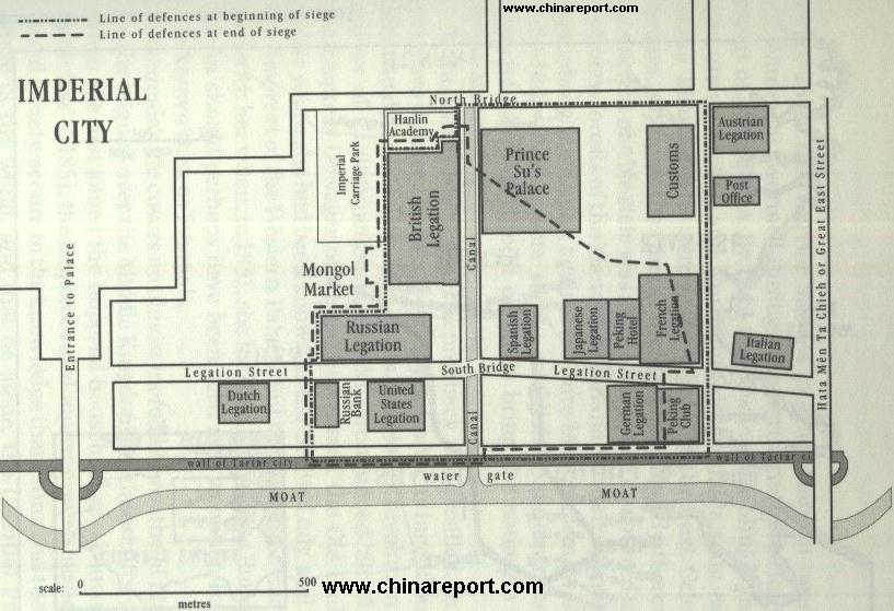
Canal Street - Before the demolition of the City Walls in the 1950's, Beijing's City Wall was intersected by an Imperial Canal leading from the Imperial City in the North, through the Legations Quarter, to the City Moat outside the Wall in the South. There it connected to the Grand Canal.
The Canal was filled in in the 1950's along with the demolition of the City Wall, creating QianMen Dajie running West to East and Zheng Yi Road, running North to South and Vice Versa. The South Bridge can still be found as a hinted bulge in the road at the height of the intersection of Zheng Yi Road and Legations Street at the former Yokohama Specie Bank turned Minsheng Bank. The North Bridge has disappeared without a trace beneath the pavements of East Chang An Avenue, widened in the 1950's for the Famous Grand Military Reviews and other mass happenings.

Rue Marco Polo or "Customs Street" - Rue Marco Polo was named so by the French and was the location of the Maritime Customs Office, an office of the Chinese Government. As a result everyone but the French had named the Street Customs Street.
The Customs Office had been located in the area since the far past days of the Yuan Dynasty in Beijing (then Khanbalik), as the important trade and supply route of the Grand Canal connected to the City to the south-east, just outside the City Walls.
Taxes were levied on the grain imports to City through this Office during the Yuan Dynasty (1271 AD - 1368 AD), Ming Dynasty (1368 AD - 1644 AD) and Qing Dynasty (1644 AD - 1911 AD). Later, during the days of The Legations the Customs Office was thoroughly modernized under Leadership of (Later Sir) Robert Hart, who lived north and adjacent the Customs Office. Due to his important role in the affairs of the Legations in Beijing the Street running eastward from the Customs Office and behind the Austro-Hungarian Legations was named Rue Hart. It was the location of the British Post Office in the Legations.
Due to  his large contribution to the modernizations of the Chinese State Machinery (and Coffers), his efforts in rescuing Chinese interest from western onslaught in the post-boxer war negotiations and more, the Street was the only street not "cleaned up" during political actions of the Cultural Revolution Era, leaving the Rue Hart Street sign the only such sign surviving in Beijing until this day.
Find the Former Rue Marco Polo or Customs Street, in the French claimed Eastern parts of the Legations Quarter connecting to QianMen East Street in the South, then intersecting with Legations Street, passing Rue Hart and the current Communist Party Branch of Beijing Headquarters to connect up with Chang An Avenue across from Wanfujing Street in the North.
More on the Legations Quarter of Beijing in our 11 Page Report + Sources Page.
French Legations
Japanese Legation
German Legation
Italian Legation
United States of America Legation
Russian Legation
Russian Bank
Dutch Legation
Austro-Hungarian Legation
Jardine Matheson & Co
  X
Japanese Legation (addition + Later Main Gate)
Temple of Heaven Park
Palace Museum
Beijing Legations Quarter
YongdingMen
DeshengMen
WanPing Village and Marco Polo Bridge
Click to Go to Map !
Satellite Image overview of Beijing Center, revealing the Old Imperial City  layout and Borders as they were (generally) until 1949.
Satellite Image Map of Chongwen District and the southern-most part of DongCheng District, clearly showing the extend of West- and East-Legations Street and the Legation Quarter of Beijing.
The former Eastern Borders of the Legations Quarter are the least interesting. In history this was a remote stretch of the Legations where the German Hospital was located. Today one can visit DongDan Park at ChongwenMen Nei Dajie', a Gay Hotspot and ChongwenMen, the location of the Former ChongwenMen Gate layed to waste by the artillery of relieving Allied Forces in the Summer of 1900 AD. It is now the beginnings of the extensive Ming Dynasty City Wall Relics Park which leads all the way to the South-East Corner Watchtower, the DongBianMen, home of the Famed Red Gate Chinese Contemporary Art Gallery.
Last but not least is QianMen East Street, which has an interesting history to it.
At the Times of the Legations between 1860 AD and beyond 1911 AD, QianMen East Street did not exist as is today. Instead the space now filled by this wide boulevard consisted of the Ming Dynasty City Wall with outside of it the City Moat. The City Moat in turn connected to the famous Ming Dynasty Grand Canal East of the Legations.
QianMen Dongdajie', at the Height of Zheng Yi Lu, was the location of a water-gate tunneling underneath the City Walls. As a result the Legations Grounds proper
were partially aligned along what is QianMen East Street today, however their Gates all were located in the North of each Legation giving access to Legations Street or what is now XiaoMin Alley.
West Legation Street
East Chang An Avenue ->
This page was last updated on: June 6, 2017
My Great Web page

View AsiaReport.com - Mastermap of Asia (entire). in a larger map
To JianGuo-Men and Chao-Yang District
Beijing Landmarks
Beijing Introduction
Beijing Online Sources
Beijing
Beijing Home
Beijing Hotels
Beijing Maps - Index
Beijing Public Transport
City Province Transport
Beijing by District(s)
Chongwen
ChaoYang
Dongcheng
Fengtai
Haidian
XiCheng
Xuanwu
6 Outer Suburbs
TiananMen Square
Alphabetical Order
By Function(s)
Forbidden City
Hebei Province
Hebei Province Home
China Offline Sources
AsiaReport.com Home
China Report Home
China Online Sources
China Online Store
China Maps
China
China Photo Galleries
China Report Club
4 Rural Districts
Shijingshan
Maps of Chaoyang
Maps of Chongwen
Maps of Dongcheng
Maps of Fengtai
Maps of Xicheng
Maps of Xuanwu
Maps of Haidian
Maps of Shijingshan
Beijing Great Wall Maps
Beijing North China Maps
Historic Maps of Beijing
BJ Public Transport Maps